Showing posts with label map art. Show all posts

Wednesday, February 2, 2022

As we warm the Arctic

As we warm the Arctic, thermochromic linocut, 9.25" x 12.5" by Ele Willoughby, 2022


I was a bit flummoxed by he #printersolstice prompt conceptual art. Then I remembered an idea I had toyed with for some time.


"This is the Arctic with the range of the polar bear: its habitat. And this is what happens when we heat it.”


This is an interactive lino block print which changes colour! A map of the Arctic looking down on the North pole is handprinted in a delicate cream colour on white Japanese kozo (or mulberry) washi paper. On top of the map, I have printed the range of the polar bear in blue complete with a polar bear and the aurora (or Northern Lights) and the word habitat in fuchsia. I have mixed the blue and fuchsia inks myself: they are made with thermochromic temperature sensitive pigments. If these inks rise about 30 degrees Celsius (70 degrees Fahrenheit) they turn colourless, so if you heat the print, for instance with a hair dryer, the range, polar bear and word habitat all disappear. The print is called “As we warm the Arctic” and is about habitat loss due to climate change.

Saturday, May 16, 2015

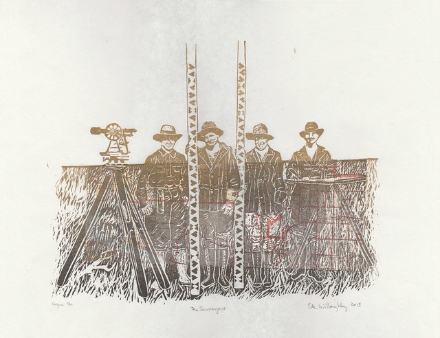
Surveyors, an all-female crew in the American west in 1918

Surveyors1
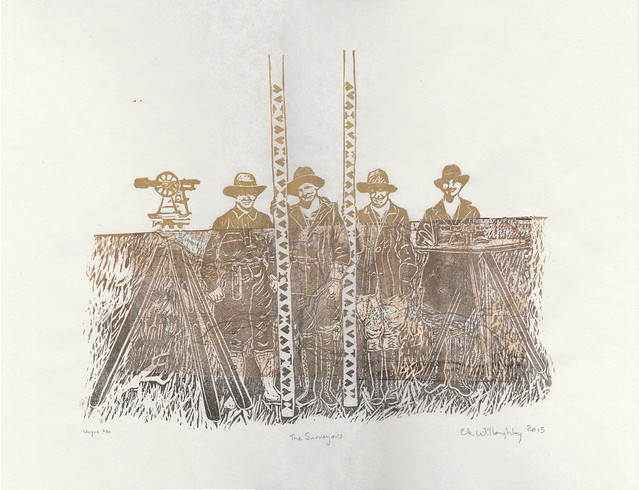
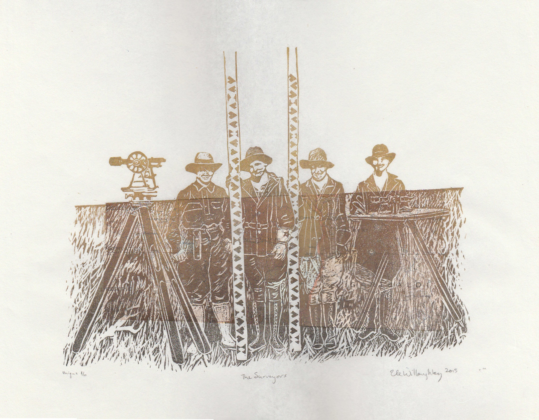
The Surveyors, linocut with vintage topographical map, 14" x 11", edition of 10 each unique, 2015 by Ele Willoughby

All female survey crew working on the Minidoka Project, Idaho, 1918.
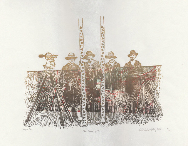
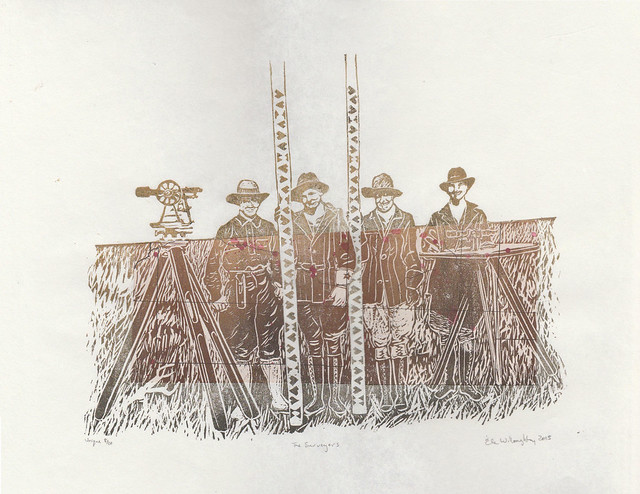
I love when people approach me about doing a fascinating custom order. An artist, Krista Caballero who has been collaborating with many others on a project called Mapping Meaning which brought together "artists, scientists and scholars to explore questions of social, mental, and environmental ecology. Inspired by a photograph from 1918 depicting an all-female survey crew, the project is rooted in a five-day experimental workshop that takes place biennially on the Colorado Plateau." She wanted to thank her collaborators with the gift of a print and wanted to know if I could make an edition inspired by this very 1918 photo. Since one of the things I do is communicate science through art with portraits of scientists (with a special focus on women in the history of science) and I have also done a variety of earth science surveys and mapping, this is very much my thing. In fact, I worry sometimes about hagiography... about only present heroes and heroines, or perpetuating the myth that science is a series the story of a series of lone geniuses. Plus, those survey rods with their odd symbols are so graphic and tempting to one who makes relief prints.

I proposed portraying these women and incorporating vintage geological, topographic and seismicity maps of the western North America, so that each print would be unique. All of the vintage maps came from the Geological Survey of Canada and were actually used in the field - as a tip of the hat to these women. I felt that any marking on the maps actually made them more app. The maps are also from western North America, and are decades old - a little further west and north, and later than these women worked... but they can be tied to similar pioneering surveying work. These hard-working women would have produced the sorts of data fundamental to producing the maps like these geological, topographic and seismicity (or earthquake) maps. The history of science is not only a series of exploits of well-known genius experimentalists, famous for their eureka moments; nor is it simply a tale of paradigm shifts brought about by wiser theorists who suddenly saw the need to shift the entire underpinnings of a given field of science. The history of science is also a tale of hard work by countless unknowns; an all-female survey crew from the early twentieth century seem especially unknown. We have no record of their names and they do not fit our preconceived notions of who explored and mapped the west, or who did fundamental scientific grunt work. I think Idaho in 1918 would still feel like the wild west and imagine these women to be quite fearless.

There are a few extra available here.

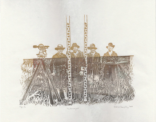
Surveyors2
The Surveyors, linocut with vintage topographical map, 14" x 11", edition of 10 each unique, 2015 by Ele Willoughby


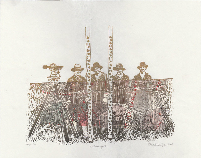
Surveyors3
The Surveyors, linocut with vintage topographical map, 14" x 11", edition of 10 each unique, 2015 by Ele Willoughby
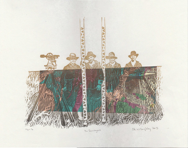
Surveyors4
The Surveyors, linocut with vintage geological map, 14" x 11", edition of 10 each unique, 2015 by Ele Willoughby

Surveyors5
The Surveyors, linocut with vintage geological map, 14" x 11", edition of 10 each unique, 2015 by Ele Willoughby

Surveyors6
The Surveyors, linocut with vintage topographical map, 14" x 11", edition of 10 each unique, 2015 by Ele Willoughby

Surveyors7
The Surveyors, linocut with vintage geological map, 14" x 11", edition of 10 each unique, 2015 by Ele Willoughby

Surveyors8
The Surveyors, linocut with vintage seismicity map, 14" x 11", edition of 10 each unique, 2015 by Ele Willoughby

And do check out Mapping Meaning - there's some very interesting stuff there!

Monday, January 21, 2013

Alberta

Alberta linocut


The symbols of Alberta, its provincial animal, the big horn sheep and its famous flower, the wild rose cover the hand-carved map of Alberta in this linocut. The block was inked 'à la poupée' (with different colours, green, pinks, yellow and gray-brown, in different areas) and printed by hand on lovely Japanese kozo (or mulberry) paper. Each print is 23.5 cm by 31.8 cm (9.25" by 12.5"). The print is one of a variable edition of eight.

It was obvious, despite the various symbols of the province from which to choose, that I needed to include the wild rose1; the licence plate of every car in the province proclaims it to be 'Wild Rose Country'. While the provincial bird, the Great Horned Owl is a wonderful subject, its range stretches far beyond the province. The mammalian emblem, the Big Horned Sheep, on the other hand, gets its very name from Canada: Ovis canadensis. Also, I liked the idea of using the shape of the province to micmic its topography. So, I imagined a scene of looking through a wild rose bush on the prarie at the base of the foothills, west towards the mountains of the Rockies and the Big Horn Sheep.

I've had the great priviledge of having seen much of this country and having travelled from coast to coast. (I am still hoping to visit the third coast). I have visited Calgary several times, and flown over the province more times than I could count. I hope one day to be able to explore more of Alberta. I know there is much beauty yet for me to discover. One Week, for instance, convinced me that I need to go to Drumheller, "Dinosaur Capital of the World"! Plus, hardy friends keep moving to Edmonton.2

1 No political overtones intended. I won't hold the, shall we say less-than-gay-positive party with the unexpectedly poetic name against the flower. The flower came first.

2 Did you know they have summer and winter electrical tape there? Do you know why? Cause regular vinyl tape can freeze solid at -40oC and cut like a knife. Or, at least so I've been told.

Wednesday, January 9, 2013

Saskatchewan, sharp-tailed grouse and Western red lily

Saskatchewan

The symbols of Saskatchewan, its provincial bird, the sharp-tailed grouse and its flower, the Western red lily cover the hand-carved map of Saskatchewan in this linocut. The block was inked 'à la poupée' (with different colours, gold, green, brown, orange and magenta, in different areas) and printed by hand on lovely Japanese kozo (or mulberry) paper. Each print is 23.5 cm by 31.8 cm (9.25" by 12.5"). The print is one of a variable edition of eight.

The Sharp-tailed Grouse, (Tympanuchus phasianellus), known as as the sharptail, fire grouse or fire bird, because they rely on brush fire to clear their habitat. The males are known for their display and courtship behaviour: stamping their feet rapidly, rattling their tail feathers, turning in circles, dancing forward, inflating and deflating their purple neck sacks, and cooing to attact the females. This is how I've illustrated the grouse. They are similiar, but not identical to the Greater and Lesser Prairie Chickens, though you often see it claimed they are one and the same. They also do some impressive fighting over the females, but how could I resist this dance:


The Western red lily is a protected species, which grows in meadows and grasslands. It has six reddish-orange petals with dark purple spots. It is also known as the Wood Lily, Philadelphia Lily, Prairie Lily or Western Red Lily, and is a perennial species of lily native to North America. It even appears on the provincial flag.

I've had the great priviledge of having seen much of this country and having travelled from coast to coast. (I am still hoping to visit the third coast). I visited Saskatchewan when I was young and found the wide open plains, and the wind in the grain, reminded me of the ocean. My grandfather grew up in Saskatchewan, and I grew up with his stories of his barefoot prairie summers and harsh Saskatchewan winters, when he needed to tie a rope between the house and barn, to avoid being lost in a blizzard, even over such a short distance.

Wednesday, December 26, 2012

New Brunswick, Black-capped Chickadee and Balsam Fir

New Brunswick linocut

The symbols of New Brunswick, its provincial bird, the black-capped chickadee and its tree, the balsam fir cover the hand-carved map of New Brunswick in this linocut. The block was inked 'à la poupée' (with different colours, black, gold and green, in different areas) and printed by hand on lovely Japanese kozo (or mulberry) paper. Each print is 21.1 cm by 20.3 cm (8.3" by 8"). The print is one of an edition of twelve.

The acrobatic, but rather tame chickadee, with its distinctive black cap, has long been one of my favorites. It's the only bird I can persuade to reply to me; it will actually answer when I cry, "Chickadee-dee-dee!" The balsam fir (Abies balsamea) is also distinctive, with narrow, flat needles are which shiny dark green above and white below and it grows large pine cones. It is native to most of eastern and central Canada and much of the northeastern US. It makes an excellent Christmas tree. Every visit to the province leaves the impression of vast, dense, forest, filled with wildlife, so covering the entire province with the depiction of a tree seemed apt.

I've had the great priviledge of having seen much of this country and having travelled from coast to coast. (I am still hoping to visit the third coast). I've visited New Brunswick several times, coming down from Québec, up from Maine or west from Nova Scotia. I've even spent a couple of frosty weeks sailing in the misleadingly-named Baie des Chaleurs. At least in October, it was anything but warm. The province is the original home of my RJH and his family, so I know I will return time and again. (In fact, I made this as his Christmas gift, but the rest of the edition can be found in my shop).

Monday, October 8, 2012

British Columbia & Happy Thanksgiving

British Columbia

The symbols of British Columbia, its provincial flower, the Pacific dogwood (Cornus nuttalli) and its animal, the Spirit Bear (also known as the Kermode bear, a white morph of the American Black Bear, Ursus americanus kermodei) cover the hand-carved map of BC in this linocut. The block was inked 'à la poupée' (with different colours, green and gold, in different areas) and printed by hand on lovely Japanese kozo (or mulberry) paper. Each print is 23.5 cm by 31.8 cm (9.25" by 12.5"). The print is one of an edition of eight.

The lovely dogwood flowers thrive along the west coast, and can even be found aas far north as Haida Gwaii. The Pacific dogwood has been a symbol of British Columbia since 1956. Once protected it is now considered secure and not at risk of extinction. The same fate is hoped for the newest symbol of the province, the Spirit Bear. This colour morph of the Black Bear is due to recessive alleles common in the population. Genetically, this means they are more like human redheads than albinos. National Geographic estimates the spirit bear population at 400-1000 individuals. Because of their ghost-like appearance, "spirit bears" hold a prominent place in the oral stories of the First Nations people of BC. They were named after the Kermode Bear after Francis Kermode, former director of the Royal B.C. Museum, who researched the subspecies.

I was never lucky enough to spy a spirit bear in the temperate rainforest of Canada's west coast, but saw many dogwood. I was a bit torn when designing this linocut. The provincial bird is the Stellar's Jay, which was very common and a bird I saw quite regularly when I lived on Vancouver Island. In the end though, there is something magical about the Spirit Bear and it was on my 'to do' list of animals to depict in linocuts.

I hope everyone celebrating had a great Thanksgiving long weekend! I know Minouette loves any holiday which involves turkey. This is a photo RJH took two years ago. He titled it "Turkey Dazed". I hope this is how you are feeling, but not too much.

turkey-dazed

Saturday, October 6, 2012

Manitoba

Manitoba

I've followed up my home province print with the home province of my mother: Manitoba.
The provincial animal the bison and flower the prairie crocus (Anemone patens) cover the hand-carved map of Manitoba in this linocut. The block was inked 'à la poupée' (with different colours, pale violet, umber and brown, in different areas) and printed by hand on lovely Japanese kozo (or mulberry) paper. Each print is 23.5 cm by 31.8 cm (9.25" by 12.5"). The print is one of an edition of seven.

It's no mystery how the bison could symbolize this prairie province. Manitoba is one of the few places where one can still find free-ranging herds of woods and plains bison. The early spring flower, Anemone patens, known as the "Prairie Crocus" was chosen by the school children as the floral emblem of the province in 1906. I imagined a bison roaming a field replete with prairie crocuses. I was sure to include Lake Winnepeg, Lake Manitoba through Lake Winnipegosis to Cedar Lake and even Reindeer Lake, because they are part of the arc of immense lakes extending from the Great Lakes which are cut into the fabric of this country.

Thursday, October 4, 2012

Ontario

Ontario

I've always been a big fan of map art - art made from maps, with maps, inspired by maps - and have recently seen several handmade items based on the shape of US states, and the Great Lakes. I noted both that Canada and its provinces are un- or underrepresented and that while the geometrical shape of a state can be interesting and graphic (and I can appreciate elegance in simplicity) it isn't really me. So the idea of making prints of Canadian provinces and territories, starting with my own, has been at the back of my mind for some time. To me, it always seemed that where I grew up was defined by the Great Lakes - perhaps because I've spent so much of my childhood driving from the shores of Lake Ontario to the mouth of Lake Superior and back. Both finding triliums in the woods and the haunting call of the loon have something of the mysterious to them, despite their familiarity and association with home for me. So covering my map of Ontario and the Great Lakes with our provincial symbols is obviously the way for me to go.

The block was inked 'à la poupée' (with different colours, black, green and yellow, in different areas) and printed by hand on lovely Japanese kozo (or mulberry) paper. Each print is 23.5 cm by 31.8 cm (9.25" by 12.5"). The print is one of an edition of eight.

Friday, February 11, 2011

urban rhythms

Using the New York City's actual subway system schedule, routes, and expected travel times, recordings of cello pizzicato and a wee bit of artistic licence, Alexander Chen has created Conductor.

Conductor: www.mta.me from Alexander Chen on Vimeo.


He chose certain parameters for aesthetic reasons (colours, fading lines, number of allowed simultaneous trains, and how to relate length to pitch). I love how both visually and audibly the lines appear to be plucked. "When a string is in the middle of being drawn by a subway car, its pitch is continually shifting." The pitch of the sound is determined by length of the straight-line segments but rather to avoid dissonance he stuck with, a "simple major C scale but with the lowest note as a raised third E, which keeps it from ever feeling fully resolved."

{via bioephemera}

Meanwhile, French artist Armelle Caron in her Anagrammes graphiques de plans de villes - 2005 / 2008 series takes cities and deconstructs them into their constituent blocks, arranges these by size and shape and reveals the inner rhythms experienced by the pedestrian - like an anagram of a sentence.*


Berlin


Paris


New York


Istanbul

{via Planetary Folklore}

Friday, July 16, 2010

secret 'editorial formula' as subway map: the moral underground


Reposted from birdgerl, it's the Tube, as explanation of the Daily Mail's editorial strategy, according to The Poke, who write
Speculation that The Daily Mail’s success was down to a top secret formula started in the late eighties, but it was dismissed as Fleet Street legend along with the real parentage of the Hitchens brothers and that thing Una Stubbs is into. Though such explicit mapping of the newspaper’s friends and enemies have set tongues wagging, the main surprise seems to have been the bizarre use of the underground system. Reports that The Daily Star’s secret formula is based on the number 10 bus route remain unconfirmed.


I'm sure this is even funnier if you know the paper's track record (and can identify everyone and everything listed). The connections between stations are funny in and of themselves ('Nigella Lawson' to 'E. Coli'?). Follow the link to read it in detail. I particularly like 'All the Redgraves', 'Rabies', 'Etonian Playboys' and 'Pidgeons'. I'm amused also that my mother would have made the 'Arch-Enemies' list as a foreign nurse when she lived in London, before I was born (even if nice Canadian girls from small-town Manitoba are not what they have in mind when they write 'foreign').

Friday, March 5, 2010

subway human anatomy map

Hey check it check it! Interior subway map:


Underskin by Sam Loman via see reqbat tumble


We should map everything with such elegance.

Tuesday, October 27, 2009

Spontaneous performance art in Parkdale

balloons in Parkdale

As I walked home along Queen St W through Parkdale, I passed the helium balloons caught in the telephone wires. The elderly man in front of me stopped. He was wearing a surgical mask and didn't look very steady on his feet, but he picked up his cane and brought it to his shoulder like a hunting rifle. He aimed at the balloons and then mimed the backfire as he shot them with his imaginary gun. One of the street punks said, "Hey old man, you living in the old days?" He pretended he didn't hear and continued on. A few paces along he found something else he thought he'd like to shoot and whipped up his cane, bringing it perilously close to my face. "Oh, I'm sorry," he said, but I merely swerved and assured him it was alright. He has the freedom to play make-believe.

evolution of the wheatpaste man

The wheatpaste man evolves. He lost his face. His sign has been defaced, and now, he has two bows.

spotsmovement
stripespaint explosion detail
behind the fence
detail of the Dufferin jog graffiticomputers
opinionated snail
flying stump face
felt hearts and stars
heart with skull and crossbones
Gnome on the tracks

Ever seen the gnome on the train tracks?

run run run with bow and bunny

I like the sneaker wearing sneakers... fractal footware.

rococco skull
tag sky over Parkdale
homes with tags
stripey tagsParkdale heart
Parkdale mural artParkdale mural
Parkdale mural globe

I sort of love the naiveté of the geography depicted. There appears to be a prototypical Frenchman, somewhere approaching Moscow, a Chinese man lost in Siberia, St. Basil's and please-tell-me-that's-not-Stalin are deep within China. Meanwhile, Brazil is north of Newfoundland and Central America didn't make the cut. In a clear indication that we do not live in igloos here, there is an igloo firmly planted in Greenland.

words on the wall

The stencil read:
You have not
yet fathomed
what a creative
entity you are
because you
doubt what you
are when you
sease [ sic] and allow
yourself to
flow forth you
will have your
perfect
instrument
of expression
simply allow you
to be and dont
compare your-
self to
anyone

Wednesday, April 8, 2009

Imaginary Subway Maps

I guess it's maps this week. I have a thing for maps and map art. I love subway maps. I love maps of imaginary places. Here is a twist: a set of subway maps of real places wherein there are are no subways.

[by Transit Authority Figures via Apartment Therapy]
Oh! This would make getting to the Woods Hole Oceanographic Institute so much easier.

They have a few other maps for smallish places in New England. I don't know the area well enough to understand all the jokes (though I am pretty sure that say 'Landfill' and neighbouring 'Polo Grounds' and well as 'Malfunction Junction' stations in Machester, Vermont are jokes, and 'Kandahar' is well, saying something; likewise 'The Bath Tub' on the Cape). Though, having drive to and around Wood's Hole, I do know that some of the least probable names are in fact legitimate.