


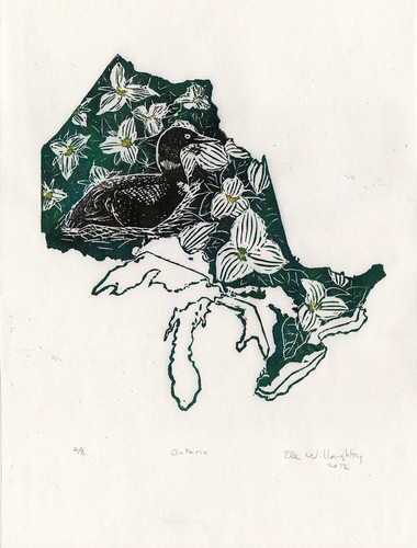
I've always been a big fan of map art - art made from maps, with maps, inspired by maps - and have recently seen several handmade items based on the shape of US states, and the Great Lakes. I noted both that Canada and its provinces are un- or underrepresented and that while the geometrical shape of a state can be interesting and graphic (and I can appreciate elegance in simplicity) it isn't really me. So the idea of making prints of Canadian provinces and territories, starting with my own, has been at the back of my mind for some time. To me, it always seemed that where I grew up was defined by the Great Lakes - perhaps because I've spent so much of my childhood driving from the shores of Lake Ontario to the mouth of Lake Superior and back. Both finding triliums in the woods and the haunting call of the loon have something of the mysterious to them, despite their familiarity and association with home for me. So covering my map of Ontario and the Great Lakes with our provincial symbols is obviously the way for me to go.
The block was inked 'à la poupée' (with different colours, black, green and yellow, in different areas) and printed by hand on lovely Japanese kozo (or mulberry) paper. Each print is 23.5 cm by 31.8 cm (9.25" by 12.5"). The print is one of an edition of eight.
2 comments:
Very cool.
Thanks very much!
Post a Comment