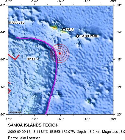
 {image from Preliminary Earthquake Report
U.S. Geological Survey, National Earthquake Information Center
World Data Center for Seismology, Denver}
At 17:48:11 UTC (which was 1:48 pm EDT) today, a magnitude 8.0 earthquake hit on the Tonga trench, just off Samoa. A tsunami has been generated. No reports yet on the number of casualties in Samoa. Authorities are monitoring the risk around the Pacific basin and in Hawaii.
When I worked for the GSC, I knew when a large earthquake hit because the seismologist on duty would run down the hallway, or I'd see it on the seismometers on display, or I'd arrive at work and there would be a news crew. It got so that seeing the news crew was like arriving at work to find the flag at half-staff. It made me sad, prior to knowing why. Now I learn these things from the American Geophysical Union twitter feed.
Earthquake prediction remains an elusive goal. Successes are few (and are either the product of dumb luck, or on the most intensively studied fault system in the world, where population density happens to coincide with wealth and the means for investment, technology and expertise on the San Andreas - and even there, while a tremendous achievement, the the prediction was more vague than one would hope). I do not think this will improve any time soon; it in in the nature of earthquakes that probabilities are likely to be the best information earth scientists can provide. Unless there is some measurable, consistent precursor yet to be discovered, or more convincingly documented, there is not much which can be done. The makes one feel helpless and frustrated. It is one reason I did some research on earthquake hazard in Cascadia (British Columbia, Oregon, Washington and northern California), which is not directly tied to the bulk of my research.
Tsunamis on the other hand, are much more predictable. Since they are triggered by things like major earthquakes, or marine slumps and slides, there are measurable precursors. In the Pacific, where industrialized nations have recognized their risk for decades*, there is a well-established tsunami warning system. There are tide gauges and wave rider buoys and satellite altimetry data all available in real-time. It's hard to think about how much of the loss of life after the Sumatran tsunami on Boxing Day, 2004 was preventable. (It was triggered by a staggering 9.2 event which released an order of magnitude more energy than today's event).
Events like these make me wish I could do something. The instrument we deployed recently, in the North Pacific has and will see the effects of this. The energy from an earthquake of that magnitude radiates outward in all directions and makes the earth ring like a bell. The oscillations will already have been recorded by our gravitymeter (which is sensitive to acceleration and hence displacement of the seafloor). This would have happened approximately 12 minutes after the event. The tsunami waves are not traveling anywhere near as fast. Should it hit Hawaii (which is not a given) it will not arrive until 7:18 EDT (23:18 UTC) and it would be hours later when and if it reaches my instrument. If it does, the differential pressure gauge will record it. The waves I use to make measurements obey the same physics and are of similar frequencies as tsunami waves. So what interests me is have we deployed an experiment meant to image what is below the seafloor, which could also provide useful additional information to either the numerical tsunami modellers or to the warning system. Then, at least, I would feel like I was doing something to help.
*or centuries, in the case of Japan. The Haida of BC preserved their memories of the 1700 event in their oral tradition. The earthquake which triggered that tsunami has been estimated to have been a magnitude 9.0.

No comments:
Post a Comment